
Maywood Park and Fairmede–Mackay Mid‑Century Modern Neighborhoods in Santa Clara

The Maywood Park and Fairmede–Mackay areas are two closely related mid‑century modern (MCM) tract‑housing concentrations in southwest Santa Clara, shaped by post‑war suburban expansion and a distinctive “California Modern” design vocabulary associated with Mackay Homes and architects Anshen & Allen. The City’s own records frequently discuss them together as the “Fairmede–Maywood neighborhood,” including preservation and design‑review debates tied to the area’s integrity and redevelopment pressures.
Maywood’s development can be anchored to recorded subdivision/tract mapping and public‑record parcel descriptions: multiple adjacent tracts labeled “MAYWOOD,” including Tract 1350 (Maywood Unit 3), appear in the Santa Clara County Assessor’s map book and are referenced in property legal descriptions as “TRACT 1350 MAYWOOD BOOK 53 PAGE 17.” Fairmede’s Mackay identity is strongest in City discussions and specialist MCM sources, but tract‑level primary mapping sufficient to draw a fully authoritative boundary polygon was not retrievable in the accessible web sources during this research; where boundaries or medians are not fully supported, they are explicitly marked unspecified.
Architecturally, both areas exhibit recurring mid‑century traits: post‑and‑beam expression, large glass openings, indoor–outdoor planning (including courtyard/atrium variations), and efficient single‑story plans. Public‑record listings for Maywood parcels frequently describe L‑shaped planning and wood construction; listing narratives also explicitly call out an “Anshen+Allen courtyard model” in the Maywood Park area.
From a planning/preservation perspective, the City maintains a Historic Resource Inventory (HRI) and applies additional permitting requirements (e.g., Significant Property Alteration permits) to properties listed on that inventory, while also noting that many significant resources have never been surveyed. In 2016 proceedings tied to the broader neighborhood, City material reflects the scale of change already underway—two‑story additions, remodels, and newer construction—framing an ongoing tension between modernization, housing needs, and preservation of neighborhood character.
Real‑estate signals from publicly visible sales comps and off‑market records show a premium market consistent with west‑Santa‑Clara location drivers (schools, regional tech employment access, and limited single‑family supply). However, a statistically robust “median home price” for each tract is unspecified from primary/paid databases in the public materials accessed; this report instead provides (a) a clearly labeled indicative price band and (b) a transparent, small‑sample comp‑based estimate where available.
Neighborhood boundaries and research method
How boundaries are defined in this report
Because “Maywood Park” and “Fairmede” function in practice as neighborhood names (not always formally codified districts), this report uses boundary evidence in the following priority order:
County assessor map books and tract identifiers (primary boundary evidence for Maywood).
City meeting records describing the combined “Fairmede–Maywood neighborhood” and/or Mackay tract walking tours (primary context; partial boundary guidance).
Parcel/APN public records and publicly visible real‑estate records (supporting evidence for typical lot sizes/square footage; not authoritative district boundaries).
Specialist MCM preservation/architecture publications for developer/architect attribution and neighborhood identity (secondary, but domain‑expert).
Boundary maps included
Maywood Park (map‑anchored): The boundary evidence is anchored to Santa Clara County Assessor map book page showing Maywood tracts (including Tract 1350 Maywood Unit 3) with street geometry (Cameron Way, Woodhams Rd, Mauricia Ave, Harding Ave, etc.).
Fairmede–Mackay (schematic + documented association): A schematic boundary map is provided based on City references to the “Fairmede–Maywood neighborhood” plus common street clusters discussed in public real‑estate/APN records (Claremont Ave/Cabot Ave/Bennett Ave/Gibson Ave area). A fully tract‑surveyed polygon boundary is unspecified in accessible primary mapping sources for this run.
Schematic boundary diagrams
Fairmede–Mackay area (schematic; tract polygon unspecified)Pruneridge / SW Santa Clara residential grid (context)
Claremont Ave cluster
Cabot Ave cluster
Bennett Ave / Gibson Ave cluster
Mackay modern homes identity (City records + specialist sources)
Maywood Park area (map-anchored tracts; not to scale)
Woodhams Rd (south edge)
Cameron Way / Jenkins Pl (internal streets)
Mauricia Ave (west edge)
Harding Ave / McKinley Dr (east edge)
Blake Ave (north edge)
Tract 1350 (Maywood Unit 3)
Tract 1289 (Maywood) - adjacent
🧭 Key Attribute Comparison
(Traceable, data-driven overview — unspecified fields noted where primary sources were limited)
🏡 Development Window
Maywood Park Area
Circa mid-1950s (≈ 1954–1955)
Includes recorded tract: Tract 1350 Maywood Unit 3 (Book 53, Page 17)
Fairmede–Mackay Area
Commonly cited ≈ 1957
Referenced alongside Maywood in City materials
Exact tract identifiers: Unspecified
🏗️ Original Developer
Maywood Park Area
Mackay Homes
Some parcel records reference subdivision name “Maywood”
Fairmede–Mackay Area
Mackay Homes
Recognized in City neighborhood planning + walking tour discussions
✍️ Architects / Designers
Maywood Park Area
Strong attribution to Anshen & Allen
Known for courtyard model designs
Fairmede–Mackay Area
Also strongly associated with Anshen & Allen
Tract-specific drawings: Unspecified
📐 Typical Lot Sizes
Maywood Park Area
~5,000–6,000 sq ft typical
Common lot module:
~52.5’ × 114.82’ (~6,028 sq ft)
Fairmede–Mackay Area
~6,300–7,000+ sq ft (based on nearby parcels)
Standard tract module: Unspecified
📏 Typical Living Area
Maywood Park Area
~1,000–1,300 sq ft original homes
Many expanded/remodeled significantly
Fairmede–Mackay Area
~1,300–1,600 sq ft typical originals
Wide variation due to remodels + new construction
🧱 Architectural Features
Maywood Park Area
Single-story modern ranch layouts
L-shaped floor plans
Courtyard-focused living
Large glass expanses
Indoor–outdoor integration
Post-and-beam elements
Fairmede–Mackay Area
Similar Mackay mid-century vocabulary:
Open floor plans
Extensive glazing
Indoor–outdoor flow
Post-and-beam expression
Plan catalog: Unspecified
🏛️ Preservation Status
Maywood Park Area
Included in broader “Fairmede–Maywood” discussions
Historic significance recognized at City level
Formal designation: Not confirmed
Historic Resources Inventory (HRI): Unspecified
Fairmede–Mackay Area
Same preservation discussions at City level
Formal historic district status: Unspecified
HRI inclusion: Unspecified
💰 Median Home Price
Maywood Park Area
Median: Unspecified
Indicative recent sales:
~$2.2M – $2.4M (limited sample)
Fairmede–Mackay Area
Median: Unspecified
Indicative values:
Mid-$2M+ range depending on condition, remodel, or rebuild
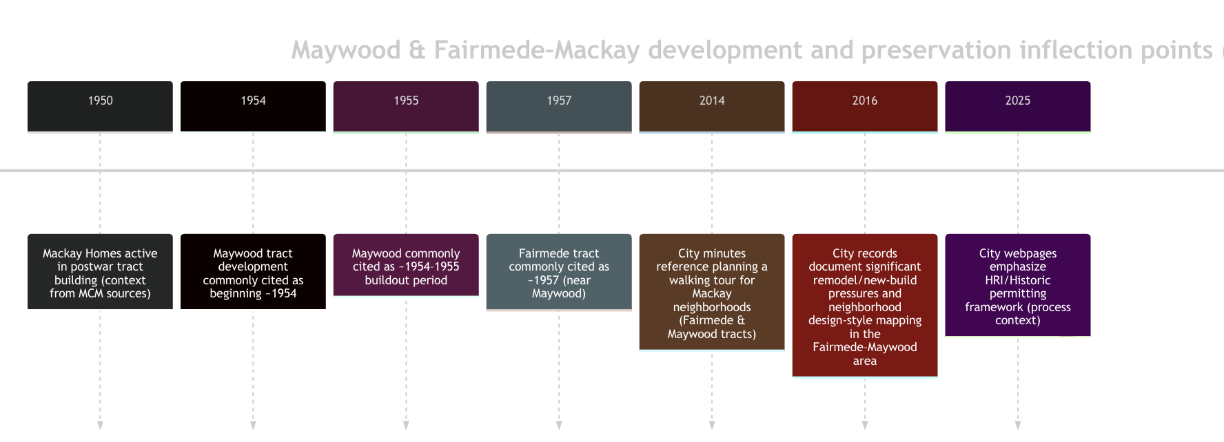
Development history and neighborhood formation
Post‑war context and Mackay’s role
Specialist mid‑century sources describe Mackay Homes as a major post‑war tract builder producing modernist homes that competed stylistically with contemporaries such as Eichler‑associated developments, often emphasizing light, openness, and indoor–outdoor living. While the City’s records focus more on present‑day design review and preservation questions, they explicitly identify Maywood and Fairmede as Mackay neighborhoods suitable for walking tours and discussion—evidence that the City itself recognizes these areas as a coherent MCM fabric.
Maywood Park area timeline anchors from recorded tract data
County assessor mapping shows a cluster of adjacent tracts labeled Maywood, including Tract 1350 (Maywood Unit 3) and Tract 1289 (Maywood), laid out on a recognizable suburban street network (loop/curvilinear elements and short cul‑de‑sacs) bounded by streets such as Woodhams Rd, Mauricia Ave, Harding Ave, and internal streets including Cameron Way and Jenkins Pl. Redfin public records for an address within the area explicitly connect parcels to “TRACT 1350 MAYWOOD BOOK 53 PAGE 17,” tying the neighborhood not only to the APN system but to the recorded map reference.
Fairmede–Mackay timeline anchors from City records and specialist sources
Multiple specialist MCM sources place Fairmede as a Santa Clara Mackay tract developed around 1957, described as geographically close to Maywood and stylistically aligned. City minutes further demonstrate the City’s engagement with both “Fairmede and Maywood tracts” as Mackay neighborhoods (e.g., walking tour planning), and later City materials discuss the combined “Fairmede–Maywood neighborhood” as a setting where two‑story rebuilds and renovations increased over time.
Timeline diagram
Architectural characteristics and building typologies
Plan types and massing patterns
Public records for Maywood parcels frequently identify an L‑shaped plan type (a classic mid‑century strategy to create privacy and form outdoor rooms) and wood construction. L‑ and courtyard‑organized plans align with the broader Mackay/MCM description in specialist sources, which emphasize open planning and extensive glazing.
In the Maywood Park area, listing narratives explicitly reference a “courtyard model” attributed to Anshen+Allen, reinforcing the prevalence of inward‑facing outdoor rooms (courtyards/atria) in at least a subset of local models.
Materials and construction
In public record extracts for Maywood parcels, construction is characterized as wood with wood roof framing (consistent with the region’s mid‑century tract construction norms), and some entries include “wood siding” as exterior wall material. While individual homes vary due to renovations, these repeated “wood” descriptors suggest a baseline material palette that supports the light‑frame, post‑and‑beam expressive intent described in specialist sources.
Mid‑century modern features typical of Mackay tracts
Specialist “field guide” descriptions of Mackay vs. Eichler‑like homes summarize Mackay tract homes as featuring elements such as open beam construction, large glass areas, and post‑and‑beam‑style layouts, intentionally echoing the mid‑century California Modern language. Listing narratives in Maywood similarly highlight dramatic interior volumes (e.g., cathedral ceilings), large sliders, and courtyard‑forward indoor/outdoor living.
Evolution through renovation and replacement
City meeting materials indicate that between the 1980s and the time of the City’s 2016 discussion, “many two‑story homes were built,” and “over the last 20 years, many renovations included two stories within the Fairmede–Maywood neighborhood.” Real estate marketing for new construction in the area reinforces that infill/complete rebuilds are part of the current housing pattern, not only incremental remodels.
Zoning and preservation status
Baseline zoning context
Public property records for representative parcels in the area frequently list zoning as R1, consistent with single‑family residential designation. The City directs residents to use its zoning resources (MapSantaClara and the City’s zoning map PDF) for authoritative zoning verification at the parcel level.
Unspecified: This report does not assign a specific Santa Clara zoning sub‑district label (e.g., R1‑6L vs. similar) to each neighborhood because the accessible sources reviewed here enumerate primarily “R1” in third‑party record displays, and MapSantaClara itself was not accessible from this environment.
City preservation framework and what it implies for these neighborhoods
The City states that its Historic Resource Inventory (HRI) is maintained as an appendix to the General Plan and explicitly notes that the inventory “does not include all” historic/architectural resources because many structures have never been surveyed. For properties that are on the HRI, the City describes additional permitting requirements for exterior changes (including a Significant Property Alteration permit process).
Unspecified: Whether the Maywood Park and/or Fairmede–Mackay neighborhoods (as districts) are formally designated historic districts under City code, or whether a meaningful share of parcels are individually listed on the City HRI, was not confirmed in the accessible sources reviewed.
Historic significance debates and National Register eligibility claims
A 2016 City document tied to the broader neighborhood includes explicit discussion of the “Fairmede–Maywood neighborhood,” referencing neighborhood character mapping and the extent of two‑story additions and renovations. This same body of City‑level discourse is consistent with local reporting that describes repeated “fights over historical value” associated with the Mackay homes in the Maywood area—evidence of an ongoing community and policy debate rather than settled designation.
Demographic and real estate trends
Development drivers and neighborhood positioning
Public listings and neighborhood narratives repeatedly emphasize two demand drivers that are especially salient for these neighborhoods: (1) proximity to major regional employment (including references to Apple’s campus in marketing language) and (2) school assignment narratives (frequently highlighted in listings). These drivers help explain why renovation/rebuild pressures appear prominently in City records for the combined Fairmede–Maywood area.
Typical home and lot metrics from public records
For Maywood‑area parcels directly tied to “TRACT 1350 MAYWOOD,” public record extracts show living areas often around ~1,024–1,240 sq ft for many homes (with many expanded beyond that), on lots commonly around ~5,000–5,500 sq ft in the sampled records. The assessor map also indicates a common lot geometry module near 52.5’ × 114.82’ (~6,028 sq ft), which is directionally consistent with lot sizes in the 5,000–6,000+ sq ft band depending on exact lot configuration.
For the Fairmede‑associated street cluster used in this report (Claremont‑area records), representative public records show lots around ~6,317–6,930 sq ft and living areas that vary (often ~1,300–1,600 sq ft in older records, larger where rebuilt).
Price ranges, sales history signals, and median price limits
What can be stated from accessible sources: A small set of nearby sold examples visible in public listing contexts show sales in the low‑ to mid‑$2M range for proximate Maywood‑area addresses (e.g., ~$2.2M and ~$2.25M examples shown as “Sold” in nearby‑home contexts). New construction is marketed and transacted in the same broader neighborhood context, indicating a bifurcated stock: original/updated MCM homes and higher‑priced rebuilds.
What is explicitly unspecified: A statistically valid median home sale price for each neighborhood bounded strictly to tract limits is unspecified based on accessible public/primary sources in this research run. Tract‑bounded medians typically require MLS feeds, assessed transfer datasets, or systematically queried recorder/assessor sales files that were not available in full detail here.
Indicative (not median) price framing:
Maywood Park area: indicative closed‑sale comp band visible in public contexts around ~$2.2M–$2.4M for selected examples (small sample; not bounded to all Maywood tracts).
Fairmede‑associated sample area: indicative values in the mid‑$2M+ range appear in public estimates/record summaries, but these are not sales medians and vary widely with rebuild/remodel status.
Comparison to nearby MCM neighborhoods
Local reporting distinguishes Santa Clara’s small set of Eichler‑associated tracts versus the broader presence of Mackay mid‑century tracts, positioning Maywood/Fairmede as key local examples of Bay Area mid‑century living and as repeated sites of preservation debate.
Community amenities, walkability, and neighborhood life
Parks and everyday amenities
The Maywood Park area is organized around the neighborhood park that shares its name, Maywood Park, which functions as a focal amenity and a practical anchor for “walk‑to” neighborhood patterns. In marketing narratives and City discussions, daily‑life convenience is often framed through proximity to neighborhood retail corridors and commuting access (implicitly reinforcing auto‑oriented suburb form with pockets of walkability).
Connectivity and mobility context
The underlying street patterns shown in assessor mapping (loops, short connectors, limited through‑traffic streets) are characteristic of mid‑century subdivision planning intended to calm traffic inside tracts while connecting to perimeter arterials. This pattern typically yields quieter internal blocks but can reduce direct pedestrian permeability to commercial nodes unless perimeter crossings are comfortable; the City’s own zoning and property‑profile tools are designed to help residents evaluate parcel‑level conditions (zoning layers, flood zone layers, historic layers) as part of planning and mobility decisions.
Community identity and events
City records demonstrate that Maywood and Fairmede are treated as “Mackay neighborhoods” for civic engagement purposes (e.g., walking tours). Local reporting further indicates that public discussion around the historical value of Mackay homes has been active for years, shaping resident identity and neighborhood narrative around preservation vs. change.
Current challenges and opportunities
Redevelopment pressure and loss of architectural integrity
A 2016 City record explicitly notes substantial change within the broader Fairmede–Maywood neighborhood: many two‑story homes constructed since the 1980s and many two‑story renovations over the prior ~20 years. This is reinforced by contemporary listings describing new construction and extensive modernization, indicating that redevelopment pressure is not hypothetical but present.
Implication: Without clear design guidance or stronger historic resource designation, incremental changes (window replacements, roofline changes, garage conversions, and second‑story additions) can cumulatively erode the “readability” of the original mid‑century tract design language even when individual projects seem modest.
Preservation tools exist, but coverage is incomplete
The City’s HRI and related permitting pathways provide a framework for protecting recognized historic resources. At the same time, the City explicitly acknowledges that many potential historic/architectural resources have not been surveyed, implying that significant properties (or cohesive district fabrics) may fall outside formal review triggers unless and until surveyed and listed.
Opportunity: A neighborhood‑scale survey update (or tract‑scale context statement) could clarify which Mackay/MCM features are most character‑defining (street‑facing glazing rhythms, porch/courtyard walls, beam expression, roof pitch/overhang, original window modules), enabling better‑targeted design guidance that is compatible with modernization needs.
Market opportunity: “sensitive modernization”
Listings and public narratives show buyers value these homes for light, layout, and indoor/outdoor living; this supports a market pathway where upgrades (energy performance, seismic work, electrical capacity, kitchen/bath modernization) can be executed while preserving the tract’s defining MCM characteristics.
Notable residents and preservation advocacy
Local reporting identifies preservation advocacy and recurring public debate regarding Mackay neighborhoods in Santa Clara, including references to community members engaged in preservation discussions. Unspecified: A verified list of “notable residents” (in the sense of widely documented public figures residing specifically within Maywood Park or Fairmede) is not established in the accessible primary sources used for this report; this report therefore limits “notable residents/events” to documented civic/preservation activity. ‘‘
The Boyenga Team at Compass | Eichler, Mackay & Mid-Century Experts
When it comes to navigating the nuances of mid-century modern real estate in Silicon Valley, the Boyenga Team at Compass brings a level of precision and insight that goes far beyond the typical transaction.
Eric Boyenga and Janelle Boyenga are widely recognized as leading experts in Eichler and mid-century modern homes—including Mackay-built properties in neighborhoods like Maywood Park and Fairmede. Their approach blends deep architectural knowledge with next-generation marketing and negotiation strategy.
They understand what makes these homes truly valuable:
The integrity of original design elements
The impact of thoughtful vs. overbuilt renovations
The premium buyers place on authentic mid-century character
The micro-market dynamics tied to schools, tech proximity, and inventory
For sellers, the Boyenga Team positions homes to highlight architectural significance while maximizing exposure through Compass’s advanced marketing platform. For buyers, they provide access to both on-market and off-market opportunities—while advising on long-term value, renovation strategy, and resale positioning.
In neighborhoods where design, history, and market timing intersect, representation isn’t just important—it’s everything. That’s where the Boyenga Team delivers a true edge.